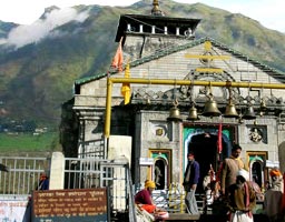
Uttarakhand lies on the southern side of the Himalayan range and the climate and vegetation vary greatly with elevation. It ranges from glaciers at the highest elevations to tropical forests at the lower elevations. The highest elevations are covered by ice and rock.
The western Himalayan alpine shrub and meadows lies between 3000-5000 meters while the tundra and alpine meadows cover the highest elevations. It gradually transforms to lands which are dominated by rhododendron. Just below the tree line lies the western Himalayan sub alpine forests at an altitude of 2500-3000 meters which transition to the western Himalayan broadleaf forests. These lie in a belt ranging from 1500 - 2500 meters.
Below 1500 meters elevation lies western end of the Terai-Duar region and the grasslands belt, and the upper Gangetic Plains moist deciduous forests. This belt is locally known as Bhabhar. These forests have mostly been cleared for agriculture, but a few of them still remain intact.
Uttarakhand has two distinct climatic regions, vis-�-vis the predominant hilly terrain and the smaller plain region. The climatic condition of the plains is very similar to the Gangetic Plain. Summers are extremely hot and winters are extremely cold while the monsoon brings in good rainfall in the whole area.